
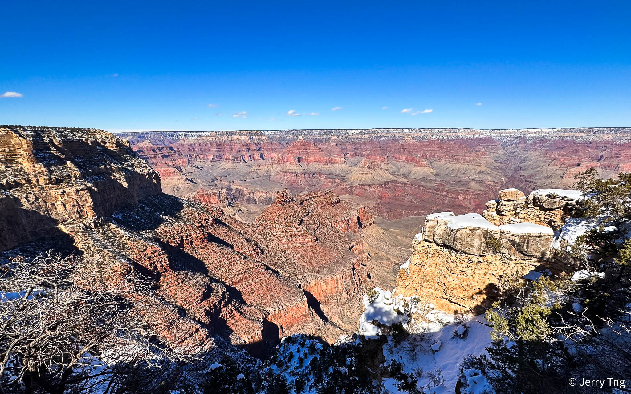
One of the interesting thing besides the magnificent view of the Grand Canyon was the span of time in geological terms that you can see along the Grand Canyon.

This was part of a full day excursion from Las Vegas that I took with Princess that included part of the Route 66 and Hoover Dam. It went all the way to the South Rim, much further from the Guano Point (Grand Canyon West) that I visited in 2004. Twenty years later the camera was better, and it was an early Spring visit and so it was snowy view that was quite rare.

Nearly 40 identified rock layers form the Grand Canyon’s walls. They have attracted students of earth history since 1858. Because most layers are exposed through the Canyon’s 277-mile length, they afford the opportunity for detailed studies of environmental changes from place to place (within a layer) in the geologic past. Geologic evolution through time can be studied through the changes between different layers.
Trail of Time

The Trail of Time is an interpretive walking trail that focuses on Grand Canyon’s vistas and rocks, encouraging visitors to ponder, explore, and understand the magnitude of geologic time and the stories told by canyon’s rock layers and landscapes.


This 4.56 km (2.83 mile) long trail is actually a geologic timeline. Walking the trail is intended to give park visitors a visceral appreciation for the magnitude of geologic time. Each metre on the trail signifies one million years of Grand Canyon’s geologic history; and bronze markers mark one metre intervals. Every tenth marker is labeled in millions of years.


Rock layers formed during the Paleozoic Era are the most conspicuous in the Grand Canyon’s walls. Coastal environments and several marine incursions from the west between 550 and 250 million years ago deposited sandstone, shale and limestone layers totaling 2,400 to 5,000 feet thick. Lizard-like animals left their footprints in Coconino Sandstone. An unconformity marks the top of this formation.

Layers from the Cambrian, Devonian, Mississippian, Pennsylvanian and Permian periods are present. Erosion has removed most Mesozoic Era evidence from the Park, although small remnants can be found, particularly in the western Grand Canyon.

Layers of Rocks


The horizontal layers were deposited as sediments, over millions of years. Each layer covered the one below. Time, pressure, and burial turned them into sedimentary rocks. 270 million years ago, this region was a tropical sea. These are the remains of animals that lived in the sea and became fossilised in the Kaibab Limestone (the top layer).
Vishnu Basement Rocks

Vishnu rocks are near the canyon’s bottom. Vishnu basement rocks formed 1,750 to 1,660 million years ago. They tell the story of how Earth’s continental crust formed in this region.


Three “Granite Gorges” expose crystalline rocks formed during the early-to-middle Proterozoic Era (late Precambrian). Originally deposited as sediments and lava flows, these rocks were intensely metamorphosed about 1,750 million years ago.

The Great Unconformity

Grand Canyon offers one of the most visible examples of a worldwide geological phenomenon known as the Great Unconformity, in which 250 million-year-old rock strata lie back-to-back with 1.2 billion-year-old rocks. What happened during the hundreds of millions of years between remains largely a mystery.
Uinkaret Volcanoes


The Uinkaret volcanic field is an area of monogenetic volcanoes in northwestern Arizona, United States, located on the north rim of the Grand Canyon. Lava flows from the Uinkaret volcanic field that have cascaded down into the Grand Canyon, damming the Colorado River, have been used to date the canyon’s carving.
Colorado River


To see Colorado River up close, you need to either walk the trail down to the riverside, or take a helicopter down from the West Rim. The Colorado River was dammed by lava flows multiple times from 725,000 to 100,000 years ago. While some believe that these lava dams were stable, lasting up to 20,000 years and forming large reservoirs, others think they failed quickly and catastrophically as massive floods (read Eagle Point legend). Lava flows traveled downriver 76 miles (121 km) from river mile 178 to 254.
Bright Angel Shale


The Bright Angel Shale consists mostly of shaly green mudstones with lesser amounts of fine-grained dark sandstones. Most of the formation is a sediment-covered slope from Cambrian Period (~510 MN years old) or platform (called the Tonto Platform) broken by low sandstone ledges. Fossils of the Bright Angel include 47 species of trilobites, inarticulate brachiopods, and primitive mollusks. These may be found in the green shales and the thin fine-grained sandstones. Tracks, trails, and burrows are also common.

Because it’s home to many of the most memorable viewpoints, the South Rim is the ideal destination for first-time Grand Canyon Visitors. If you have small children, you may prefer to visit the South Rim for its many amenities and activities.
Visited Jan 2023
The Grand Canyon
The Grand Canyon in Arizona is a natural formation distinguished by layered bands of red rock, revealing millions of years of geological history in cross-section. Vast in scale, the canyon averages 10 miles across and a mile deep along its 277-mile length. Much of the area is a national park, with Colorado River white-water rapids and sweeping vistas. It took 3-6 million years to form; erosion continues to this day to alter its contours.

The Canyon is generally divided into four main tourist areas:
- South Rim: The South Rim is the most popular destination for Grand Canyon visitors. Managed by the National Park Service, the South Rim is home to many of the most iconic viewpoints, as well as numerous hotels and attractions.
- North Rim: Also managed by the National Park Service, the North Rim provides a rugged alternative to the South Rim.
- West Rim: The Grand Canyon West tourist region is closer to Las Vegas than the popular South Rim. The West Rim is owned and operated by the Hualapai Indians, and is known for its viewpoints and the breathtaking glass Skywalk.
- East Rim: The East Rim of the Grand Canyon is the least accessible region and its not owned or maintained by any official organizations, but there are many unique viewpoints to explore, including Horseshoe Bend.

Grand Canyon didn’t become a national park until 1919. Although the Grand Canyon may seem like an obvious choice for a national park, the first attempt to organize Grand Canyon as a national park was made in 1882, and it was shot down. In fact, the canyon didn’t become a national monument until 1908, and then it took 11 more years to finally establish it as a national park. The reason for the delay? Land and mining moguls who were concerned that the classification would restrict their access to the area.
Thank goodness there were some righteous men in government back then.
#GrandCanyon #NorthRim #SouthRim #GrandCanyonWest #Hualapai #SouthRimTrail #GrandCanyonNorthRim #GrandCanyonSouthRim #GrandCanyonNationalPark
0 comments on “Grand Canyon – Million Year Walk”