If you are going to visit Grand Canyon from Las Vegas, you have several choices. You can join a day excursion with the multiple tour agencies; you can self-drive to the edge of the Grand Canyon; or you can fly there using an helicopter.

Grand Canyon helicopter Falcon flight is the perfect way to capture the overwhelming vastness and awe by flying inside the Grand Canyon itself. Flight distance above and below the rim of Grand Canyon: 15 miles. Total flight time: 85 minutes. Total flight distance: 120 miles

You take off from the air field for helicopters next to the Las Vegas Harry Reid International Airport.

The ride will take you across Boulder City towards Hoover Dam and Bypass Bridge as you fly towards the Grand Canyon. Established in 1931 to house the builders of Hoover Dam, Boulder City, Nevada now brims with cute shops, killer cafés, and an Art Deco aura. Fewer than 30 miles southeast (but an entire world away) from Las Vegas, this charming southern Nevada burg is a hub for history and adventure at Hoover Dam, Lake Mead National Recreation Area, the Colorado River, and beyond.
Hoover Dam and Bypass Bridge

Standing proudly as a symbol of what people can accomplish during even the toughest of times, Hoover Dam serves more than 7 million visitors each year and is one of Nevada’s most popular tourist attractions. Hoover Dam lies at the intersection of the southeast corner of Nevada and the northwest corner of Arizona and impounds Lake Mead, which is the largest reservoir by volume in the United States when it is full.
The Mike O’Callaghan–Pat Tillman Memorial Bridge is an arch bridge in the United States that spans the Colorado River between the states of Arizona and Nevada. Also called Bypass Bridge, construction began in 2005 and was completed in 2010. The bridge spans 1,900 feet across the Colorado River, providing a much-needed and safer alternative to the original road on the dam.

One of the interesting things we observed along the way was how low the water level in Lake Mead was. A high-water mark or bathtub ring was visible on the shoreline on this visit in Oct 2023. Lake Mead is the largest man-made reservoir in the United States, spanning over 110 miles long in Nevada and Arizona. When Lake Mead is at its fullest, it boasts 759 miles of shoreline, is 532 feet deep, has 247 square miles of surface and astounding 28 millions-acre feet of water.

Explore brilliant blue water and striking landscape view at Lake Mead Dam. Lake Mead National Recreation Area is known for rugged mountains, canyons, and shimmering water, serving as the perfect place for visitors to boat, hike, cycle, and camp.

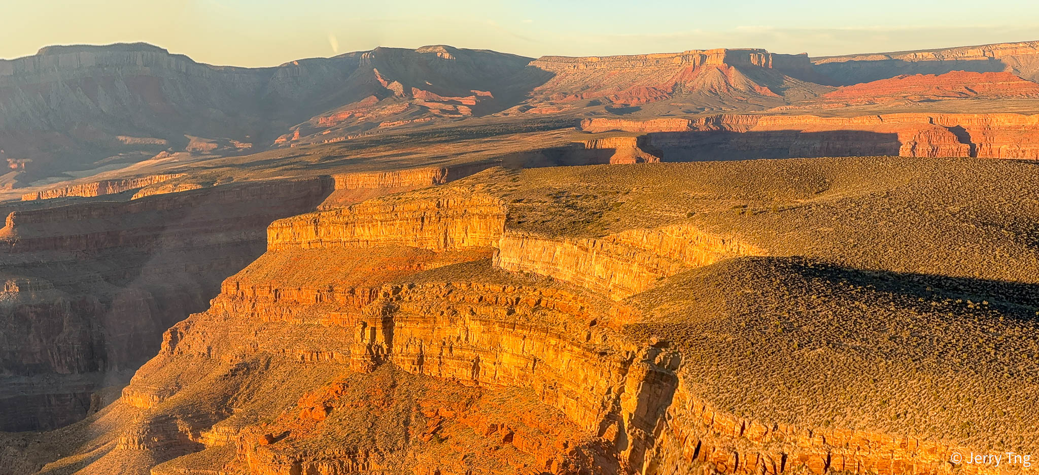
Grand Canyon

Upon arriving at the entrance to the magnificent Grand Canyon, you will begin to descend below the rim of the Grand Canyon West. You will soar like a falcon, above the Colorado River and experience vivid colours, cathedral buttresses, side canyons and rock pillars around every corner. You can only do this here because it is not part of the National Park system.

Grand Canyon West is not part of Grand Canyon National Park but instead sits on Hualapai Tribal lands—108 miles of which run along the western end of the Grand Canyon and Colorado River. This side of the canyon is more desert-like with elevations that average 4,000 feet, and it remains warmer in the summer.

The Hualapai people, which means the ‘People of the Tall Pines‘ have inhabited this area since A.D. 600 and culturally identify as part of the Pai Yuman which includes the Havasupai and Yavapai.

Rock layers formed during the Paleozoic Era are the most conspicuous in the Grand Canyon’s walls. Coastal environments and several marine incursions from the west between 550 and 250 million years ago deposited sandstone, shale and limestone layers totaling 2,400 to 5,000 feet thick.

Layers from the Cambrian, Devonian, Mississippian, Pennsylvanian and Permian periods are present. Erosion has removed most Mesozoic Era evidence from the Park, although small remnants can be found, particularly in the western Grand Canyon.

The Grand Canyon itself is a late Cenozoic feature, characteristic of renewed erosion during this time. Vigorous cutting by the snow-fed Colorado River carved the Canyon’s depth. Canyon widening is held in check by the region’s dry climate. The asymmetry between rapid downcutting and slow widening results in the Grand Canyon rather than a more typical broad (and nondescript) river valley.

Although violent storms may send flash floods gouging down narrow side canyons, the lack of steady moisture has created a stark landscape of mostly naked rock. Harder, erosion-resistant rocks such as the Coconino Sandstone and the Redwall Limestone have eroded into bold cliffs. Softer layers melt into slopes like the Tonto Platform (Bright Angel Shale) and the Esplanade (Hermit Shale). The oldest, crystalline rocks are chiseled into the craggy cliffs of the Granite Gorges.
Colorado River


The Colorado River flows nearly 1500 miles from the Rocky Mountains to the sea in Mexico. Along its way, the river traverses some of the driest and hottest areas of the country, providing drinking water to 40 million people, including some of the nation’s largest cities like Los Angeles, Phoenix, Las Vegas, and Denver, as well as 30 federally recognised Tribes.


The Grand Canyon is the iconic heart of the Colorado River. This 277-mile stretch of river in Northern Arizona is unmatched in nature. Recognised as a World Heritage Site, one of the Seven Natural Wonders of the World, and one of the most famous landscapes on earth, the Grand Canyon is the foundation of the Colorado River Basin’s natural and cultural fabric, and the National Park draws millions of visitors each year.

Hoover Dam in Nevada was completed in 1936 and backs up water to form Lake Mead – the largest reservoir in the US – backing up the river 65 miles at its longest reach to Pearce Ferry at the western end of Grand Canyon.

Your return flight will include panoramic sights of other natural wonders, including rock formations of the rugged Mojave Desert wilderness and returns over fabulous the Las Vegas Strip Hotels.
Valley of Fire

On the way back you will see the Valley of Fire, which consists of bright red Aztec sandstone outcrops nestled in grey and tan limestone mountains. The sandstone is from the Jurassic period and is the remnant of the sand left behind by the wind after inland seas subsided and the land rose. Early man moved into southern Nevada as far back as 11,000 years ago.

The most obvious evidence of occupation is the petroglyphs carved into the rocks by the Basketmaker culture about 2,500 years ago, followed later by the Early Pueblo culture. Paiutes were living in this area in 1865 when Mormons settled at nearby St. Thomas at the south end of the Moapa Valley. Farming, ranching and mining occurred in the region along a narrow stretch of water.
Las Vegas Strip

Depends on the timing of your flight, you can get to see the neon lights of Las Vegas in its splendour as you descend into the Strip. My booking was for 4.30pm and sunset for that day was 5.22pm. So we got the Grand Canyon and Sin City in all its glory.
As you go back to Las Vegas in the dusk, you may be able to catch a glimpse of the Sphere as you approach the Strip.
Here’s the 85 mins helicopter ride snipped into 3.5 min. Hope you enjoy it.
The Grand Canyon
The Grand Canyon in Arizona is a natural formation distinguished by layered bands of red rock, revealing millions of years of geological history in cross-section. Vast in scale, the canyon averages 10 miles across and a mile deep along its 277-mile length. Much of the area is a national park, with Colorado River white-water rapids and sweeping vistas. It took 3-6 million years to form; erosion continues to this day to alter its contours.

The Canyon is generally divided into four main tourist areas:
- South Rim: The South Rim is the most popular destination for Grand Canyon visitors. Managed by the National Park Service, the South Rim is home to many of the most iconic viewpoints, as well as numerous hotels and attractions.
- North Rim: Also managed by the National Park Service, the North Rim provides a rugged alternative to the South Rim.
- West Rim: The Grand Canyon West tourist region is closer to Las Vegas than the popular South Rim. The West Rim is owned and operated by the Hualapai Indians, and is known for its viewpoints and the breathtaking glass Skywalk.
- East Rim: The East Rim of the Grand Canyon is the least accessible region and its not owned or maintained by any official organizations, but there are many unique viewpoints to explore, including Horseshoe Bend.

Grand Canyon didn’t become a national park until 1919. Although the Grand Canyon may seem like an obvious choice for a national park, the first attempt to organize Grand Canyon as a national park was made in 1882, and it was shot down. In fact, the canyon didn’t become a national monument until 1908, and then it took 11 more years to finally establish it as a national park. The reason for the delay? Land and mining moguls who were concerned that the classification would restrict their access to the area.
Thank goodness there were some righteous men in government back then.
#GrandCanyon #NorthRim #SouthRim #GrandCanyonWest #Hualapai #SouthRimTrail #GrandCanyonNorthRim #GrandCanyonSouthRim #GrandCanyonNationalPark
0 comments on “Grand Canyon – From The Air”